Precision Aerial Surveys, Photography, and Videography for Arizona Projects
Unrivaled Aerial Perspective for Arizona Operations
For any aerial survey requirement across Arizona, Sedona Helicopter Charters delivers comprehensive options leveraging the unique capabilities of helicopters for low-altitude flight and precise hovering. We facilitate advanced data acquisition, including magnetometer and electromagnetic surveys, LiDAR mapping, and detailed GIS integration, providing superior insights for infrastructure and land management. Additionally, we specialize in high-definition aerial filming and photography services, offering access to sophisticated cinematographic and photographic technology, including customized aircraft configurations like door removal for specialized handheld operations. We provide the essential resources for precise aerial data collection and compelling visual documentation across the diverse landscapes of Arizona.

Aerial
Surveys
LiDAR, GIS Maps, FLIR, HD Video & More
Sedona Helicopter Charters provides the necessary resources for critical infrastructure projects, from precise pipeline assessments to comprehensive right-of-way inspections and transmission line patrols. We ensure the availability of highly suitable aircraft and specialized equipment, operated with the proficiency required to execute your project with exceptional accuracy and operational integrity. Our focus is on delivering precise and effective aerial support for your essential infrastructure maintenance needs.
High Tech Results
The Top Pilots in Arizona, Today's Technology... Maximum Results.
Call 1-866-826-4826 Now!
Sedona Helicopter Charters provides the tools needed to complete your land surveys, utilizing the right equipment to provide the aerial photos that are often needed.
An effective aerial survey significantly simplifies complex commercial and infrastructure projects across Arizona, from thorough right-of-way and site inspections to precise topographical data acquisition and high-resolution imaging. Helicopter surveys provide an unmatched vantage point for assessing the challenging Arizona terrain, enabling efficient detection of pipeline anomalies, identifying issues with transmission lines, and capturing critical video and photographic documentation of properties. Sedona Helicopter Charters excels in developing bespoke photographic and remote sensing operations, engineered to maximize both technical efficacy and financial prudence, thereby ensuring superior project outcomes.
Helicopters possess distinct operational advantages over fixed-wing aircraft for detailed aerial surveying due to their ability to fly at significantly lower altitudes and reduced airspeeds. While FAA regulations mandate fixed-wing aircraft maintain a minimum of 1,000 feet above the highest obstacle, helicopters can operate precisely closer to the terrain. This unique capability allows for the close inspection of challenging or hazardous zones across Arizona, providing engineers with an unparalleled and otherwise unattainable perspective for critical assessment and data collection.
There is no better way to conduct your visual survey, animal population counts, soil drainage analysis, ROW inspections, pipeline and transmission line inspections, and geographical surveys.
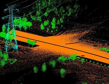
LiDAR Imaging
Light Detection and Ranging, or LiDAR, is a remote sensing method used to examine and measure Arizona topography as well as objects, like vegetation, upon it.

Infrared Imaging
Thermographic IR cameras are used to detect radiation in the long-infrared range of the electromagnetic spectrum and produce images of that radiation, called thermograms.

HD Video Gimbal Capture
Modern HD and 4K cameras can be mounted to helicopters, using the proper STCs, with a gimbal to stabilize photos & videos for detailed results.

Elevating Visual Productions with Advanced Aerial Filming
For expert camera work in the Sedona Sky
Get a Fast, free QuoteSedona Aerial Cinematography
Sedona Helicopter Charters provides comprehensive access to professional-grade aerial cinematography resources throughout Arizona. Our network facilitates custom production requirements utilizing state-of-the-art technology, including advanced gyro-stabilized camera mounts such as Tyler Mounts, Wesscam, Cineflex, Pictorvision, and SpaceCam. We support a diverse array of specialty cameras, including Cineflex HD, RED Epic, and Arri Alexa, alongside 3D and experimental camera systems. Whether your project demands intricate air-to-air or compelling ground-to-air shots, we meticulously support all facets of your production goals. Our operational expertise ensures the precise visual results required by aerial Directors of Photography and production teams. Specializing in helicopter services for both still and motion photography, Sedona Helicopter Charters is equipped to support nearly every media-related operation across Arizona, including feature films, television productions, documentaries, promotional videos, commercials, aerial prop deployment, newsgathering for television networks, and extensive coverage of major historical and sporting events, leveraging a diverse fleet of helicopters to meet exact specifications.
Call Us Today at 1-866-826-4826 for a Free Quote
Contact Us
Aerial Photos
Hand-held or Mounted OpTions in Sedona
We will help you get the right equipment for your aerial photography project! Call 1-866-826-4826 today to get a fast, free quote.
The Most Options for Photography
Arizona's spectacular and breathtaking landscapes are best captured from an aerial perspective. Sedona Helicopter Charters specializes in aerial photography charters meticulously designed to exceed your visual objectives, enabling you to capture the precise imagery you envision. We are committed to providing cost-effective photographic opportunities of this caliber across Arizona. Many helicopters can be configured with the door removed for agile handheld projects; for enhanced stability and precision, please inquire about our advanced gyro-stabilized mount options, ensuring superior image quality for your most demanding projects.
Superior Service
Every one of our customers gets a dedicated helicopter expert to assist with flight plans, tech loadouts, production logistics, project schedules, and other demands.
Over 500 Aircraft
Our network of direct air partners extends well beyond Sedona, Arizona. This allows us to offer a wide range of solutions for even the most sophisticated projects.
The Best Equipment
From high-tech sensors like LiDAR, FLIR, and GIS to HD cameras and movie production gimbals, we're here to make your job as easy as possible.